
Page 36 - Demo
P. 36
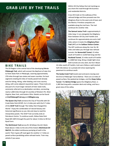
Within Oil City follow the trail markings as you share the road through the business and residen%u019fal districts.Cross Oil Creek on the walkway of the railroad bridge and then proceed over the Allegheny River to the west end of town and the Marina. Primi%u019fve campsites are available along the trail here. The trail con%u019fnues for another mile.The Samuel Justus Trail is approximately 6 miles long. It runs alongside the Allegheny River between Oil City and Franklin and con%u019fnues for approximately one and a half miles where it meets the Allegheny River Trail (ART) at the Saltbox Visitors Center. The ART con%u019fnues along the river for 28 miles and takes you through two railroad tunnels: the Kennerdell Tunnel, 15 miles south of Franklin is 3,350 feet long and the Rockland Tunnel, 21 miles south of Franklin is 2,868 feet long. Bring a bright light since both tunnels are very dark, but fun! About 14 miles south of Franklin, trail users follow a well-marked half-mile detour on a private dirt drive rejoining the pavement to con%u019fnue south. The Sandy Creek Trail travels east and west crossing over the Erie to Pi%u01a9sburgh Trail at Belmar. There are 12 miles of paved surface, five pedestrian bridges, and the Deep Valley Tunnel. The Belmar Bridge spans the Allegheny River, is 1,385 feet long with a wooden deck and railing, and has a great view of the valley.GRAB LIFE BY THE TRAILS36B I K E T R A I L SThe Oil Region is the central hub of the developing Erie to Pi%u01a9sburgh Trail, which will connect the Bayfront of Lake Erie to Point State Park in Pi%u01a9sburgh, covering approximately 270 miles through two states and seven coun%u019fes. Six local segments totaling 65 miles of mostly paved trail already exist for biking, hiking, roller blading, and cross country skiing, with some adjacent equestrian space. These trails are also part of a much larger network of inter-state trails, commonly referred to as des%u019fna%u019fon corridors, connec%u019fng nearly 1,600 miles through 53 coun%u019fes of Western PA, West Virginia, New York, and Eastern Ohio. Details can be found at EriePi%u01a9sburghTrail.org and OilRegion.org.The Queen City Trail connects the City of Titusville with Oil Creek State Park (OCSP). Its 1.4 miles join with the 9.7 miles of the OCSP Trail through \World.%u201d Enjoy the combina%u019fon of natural beauty and historical significance as you ride and stop to read the interpre%u019fve panels. The OCSP Trail currently ends at Petroleum Centre. To con%u019fnue south, follow State Park Road (SR 1007) through the park for about 3 miles to SR 8 at Rynd Farm.The McClintock Trail (across Rt. 8) follows the dirt Waitz Road about 2 miles to the site of the historic McClintock Oil Well #1, the oldest con%u019fnuous pumping oil well in the world. Then it goes off road again for another 1.7 miles on paved surface paralleling ac%u019fve railroad tracks. Train may whistle if you wave.Rockland Tunnel
